 To get to Machu Picchu you need to first make your way to the city of Cusco in Peru which is the city and airport closest to the Machu Picchu archaeological site. Click here for information on how to get to Cusco. From Cusco you then usually make your way to the town of Ollantaytambo and then on to Machu Picchu Town also known as Aguas Calientes.
How To Get To Machu Picchu Map
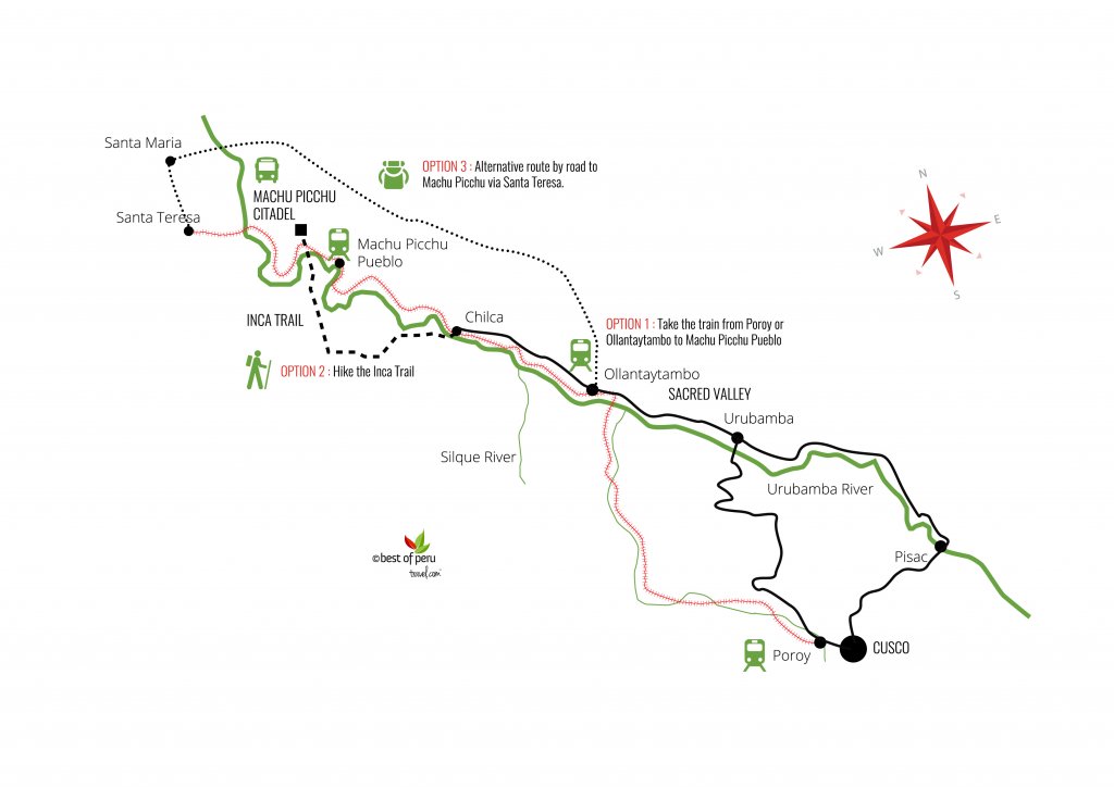
Getting from Ollantaytambo to Machu Picchu Town (Aguas Calientes):
Option 1: By Train
Journey time: 90 minutes.
Distance: Approximately 43km by railway.
Road type: This is a railway train route only with great views of the Andes mountains and the Vilcanota River.

Most people get the train from either Cusco (4 hours), Urubamba (3 hours) or Ollantaytambo (2 hours) to the town of Machu Picchu Pueblo which is also known as Aguas Calientes. There are numerous train departures every day by both PeruRail including their luxury option of the Belmond Hiram Bingham Train and Inca Rail, but do book your train tickets well in advance particularly in high season as it gets very busy.
Bear in mind that when you reach Machu Picchu Pueblo on the train you then have to either get a bus or walk to reach the Machu Picchu archaeological site itself.
Option 2: Walk the Inca Trail
Journey time: The classic Inca Trail hike takes 4 days.
Distance: Approximately 42km
Road type: This is an unpaved mountain trail that runs through the Andes.
Thousands of people every year opt to hike the Inca Trail which is typically a four day guided hike that begins at Km82 (82 kilometres along the train tracks between Cusco and Machu Picchu). Only 500 people are permitted to hike the Inca Trail at any one time so you must book your visit well in advance with an authorized tour operator. Click here for a list of tour operators authorized by the Peruvian Ministry of Tourism. You will arrive through the Sun Gate right up at Machu Picchu. There is no direct access from here to the ruins however and you will have to return to the main entrance to gain entry into the Machu Picchu citadel.
Option 3: Alternative Route to Machu Picchu via Santa Teresa
Journey time: Approximately 4 hours from Ollantaytambo.
Road type: The road to Santa Maria is a windy, narrow road with steep precipices on one side almost the whole way. The road is paved except in small sections until Santa Maria so is reasonably comfortable but the deep precipices do make for a heart-stopping journey. The road from Santa Maria to Santa Teresa is unpaved and mostly single lane. Try to avoid this route at night and in the rainy season (Dec – March) as landslides are common.
Option 1:
Hire a taxi to take you from Cusco directly to Santa Teresa. Approximately 4 hours from Ollantaytambo (S/.350 Approx. US$125 ) and 6 hours from Cusco. Cost S/.450 Approx. US$.160). Once you arrive in Santa Teresa take the train the 12km to Aguas Calientes or walk along the train tracks (Approx. 2.5hours)
Option 2:
Take the bus from Cusco (Santiago bus terminal) to the jungle town of Santa Maria. (Approx. 5 hours and 15 soles Approx. US$5.35 ) Then take a colectivo (6 soles approx. US$2.15 ) or shared taxi (10 soles approx. US$3.60) on to the town of Santa Teresa. (approx. 1.5 – 2 hours depending on the state of the road.) Once you arrive in Santa Teresa take the train the 12km to Aguas Calientes or walk along the train tracks (Approx. 2.5hours)
Notes:
- Make sure you have a good driver who is ok with driving slowly around hair-pin bends – over 100 of them! Views are spectacular.
- The road from Santa Maria to Santa Teresa is unpaved and mostly single lane. Try to avoid this route at night and in the rainy season (Dec – March) as landslides are common and you have to make your way across many streams/small rivers and multiple sharp bends. The numerous road-side crosses say it all about this section of the road…
Getting from Machu Picchu Town (Aguas Calientes) to the Machu Picchu Ruins:
Option 1: By Bus
Journey time: 25 minutes.
Distance: Approximately 43km by railway.
Road type: This is a narrow unpaved road with a series of switchbacks that brings you up to the entrance of the ruins.

Once you arrive in Machu Picchu Pueblo, walk out of the train station and straight through the market stalls until you reach a foot bridge. Cross this foot bridge and you will see below the office where you can buy bus tickets to Machu Picchu on the Avenida Hermanos Ayar. Buses depart a little further down the road on the right hand side. You can’t miss the bus departure point as there are usually long queues. Journey time from Machu Picchu Pueblo/Aguas Caliente to the Machu Picchu ruins is approximately 25 – 30 minutes. Tickets cost US$24 return for adults and US$12 return for children. Peruvian adults pay US$15 return and Peruvian children US$8 return.
Watch our video on what to expect getting to Machu Picchu:
Option 2: On foot.
Journey time: Approximately 1 – 2 hours depending on your fitness level.
Distance: 8km
Road type: This is a hike up a steep series of steps that follows the same route as the bus. There are paved and unpaved sections on the trail.
 There is an alternative 8km route on foot from Machu Picchu Pueblo up to the ruins for those that are in good physical shape only. Follow the main road out of town towards the Machu Picchu ruins. Once you cross the Puente Ruinas or Ruinas Bridge on the right, a series of steep steps will lead you up the same switchbacks the bus takes to the entrance of Machu Picchu. Allow 1-2 hours for the ascent and 1 hour for the descent. Steps are slippery when it rains. (Note: This is a very steep climb and after seeing many travellers arrive at the entrance to Machu Picchu red-faced and exhausted we recommend that you save your energy for climbing Huayna Picchu or Machu Picchu Mountain as you don’t get any special or ‘extra’ views on this hike that you don’t see on the bus up.)


